Maps are more than just navigational tools; they are windows into history, culture, and human ambition. From ancient times to the digital age, maps have not only guided us but have also captivated us as intricate works of art. This article explores the rich history of the art of cartography and how maps have evolved into masterpieces that blend science and culture, shaping our understanding of the world.
The Origins of Cartography: More Than Just Navigation
Cartography, the art and science of map-making, has been around for thousands of years. The earliest known maps date back to ancient Babylon, around 600 BCE, where maps were used not just to chart territory but to symbolize power and spiritual beliefs. The Babylonian World Map, for instance, depicted the known world as a flat disc surrounded by a mythical ocean, blending geography with the cosmic beliefs of the time.
In many ancient cultures, maps were tools of both exploration and representation. Egyptian tombs featured maps of the afterlife, illustrating a journey through the underworld. In ancient Greece, philosophers like Anaximander created maps based on their understanding of the Earth as a cylindrical shape. These early maps were not just functional but also served as a canvas for ideas, beliefs, and worldviews.
Maps as Storytellers: Artistry in Ancient and Medieval Cartography
During the medieval period, maps became even more elaborate. They were often infused with religious symbolism and allegorical figures. One of the most famous examples is the Hereford Mappa Mundi, created around 1300, which represents a blend of cartography and theology. The map does not just show geographical locations but also includes biblical stories, mythical creatures, and historical events, illustrating how people of the time understood their place in the cosmos.
The craftsmanship of these medieval maps is striking, with intricate borders, illustrations of cities, and figures representing the winds. Artists often worked hand-in-hand with cartographers to create these works, which were as much about storytelling as they were about navigation. The maps themselves became pieces of art that could be displayed as symbols of knowledge and authority.
The Renaissance: When Maps Became True Masterpieces
The Renaissance era marked a golden age for cartography, as map-making became more precise and artistic. With the explosion of global exploration, the demand for accurate maps grew, and mapmakers like Gerardus Mercator revolutionized the field. Mercator’s projection, which allowed for more accurate navigation at sea, is still used today, but it is the artistic elements of these maps that truly stand out.
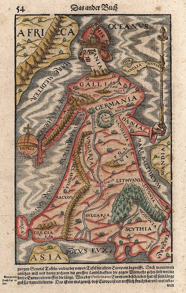
Maps from the Renaissance often featured elaborate borders, rich colors, and detailed illustrations of sea monsters, ships, and distant lands. They were both functional tools for explorers and status symbols for wealthy patrons. Mapmakers worked closely with artists to create visually stunning pieces that celebrated the new discoveries of the age. These maps became prized possessions, displayed in the homes of the elite, and used to assert power and influence.
Maps and Power: How Nations Used Cartography to Assert Dominance
Throughout history, maps have been instruments of power. As nations expanded their empires, they used maps to claim and control vast territories. Monarchs and rulers commissioned cartographers to create maps that glorified their reign and exaggerated their territorial claims. These maps were often used as propaganda, shaping the public’s perception of the world and the empire’s dominance.
One notable example is the 16th-century maps of the Spanish Empire, which depicted its territories as larger and more important than they were. This manipulation of cartography not only asserted Spain’s dominance but also helped justify its colonization efforts. Maps were also used during conflicts, with military leaders relying on them to strategize and plan invasions. In this way, cartography became a weapon of both war and diplomacy.
Cartography as a Scientific Art Form
The 17th century saw a shift in cartography as scientific advancements improved the accuracy of maps. The rise of topographical and geological mapping added a new dimension to the field, blending science and art. Maps were no longer just about illustrating borders or territories; they began to include detailed information about the landscape, such as mountains, rivers, and natural resources.
John Snow’s famous cholera map from 1854 is a prime example of how cartography can be used for scientific purposes. By mapping the locations of cholera outbreaks in London, Snow was able to identify the source of the disease—a contaminated water pump—and help stop the epidemic. This map was not just a tool for navigation but a key to solving a public health crisis.
Modern art of cartography
Today, cartography has entered the digital age, with technology allowing for the creation of highly detailed and interactive maps. Digital maps are used for everything from navigation to data visualization, but the artistry of cartography remains. Modern mapmakers continue to blend form and function, creating maps that are both useful and visually stunning.
Artists are also using maps as a medium for creative expression. Contemporary cartographic art often reimagines traditional maps, using them to explore themes of identity, memory, and place. These artistic maps may not always be geographically accurate, but they capture the essence of the places they represent, much like the maps of centuries past.
Why Maps Will Always Be More Than Just Tools
Maps have come a long way from the flat, symbolic representations of ancient times. They have evolved into intricate works of art that tell stories about the world and the people who inhabit it. Whether used for navigation, exploration, or expression, maps will always hold a special place in both science and art. As technology continues to advance, it is clear that cartography will remain a vital and dynamic field, blending creativity with precision, and art with function.
FAQs
- What is cartography?
Cartography is the art and science of map-making, blending geographic knowledge with artistic representation. - How did maps evolve into works of art?
Maps became artistic masterpieces during the Renaissance when explorers and patrons demanded more detailed and ornate representations of the world. - What role did maps play in empires?
Maps were used by empires to claim territories and project power, often exaggerating the size and importance of their domains. - What is an example of cartography in science?
John Snow’s cholera map is a key example, using cartography to identify the source of a deadly outbreak in 1854. - How has modern technology influenced cartography?
Digital tools have enhanced the accuracy of maps while allowing for creative expression through data visualization and interactive mapping.
Key Takeaways
- Maps have always been more than just navigational tools; they are works of art and power.
- The Renaissance marked a golden age for cartography, blending science and artistry.
- Cartography continues to influence both art and science, from historical maps to modern digital visualizations.


